Aim:
This lab activity aims to determine the elevation of a point concerning a reference elevation using the Fly Leveling technique.
Theory:
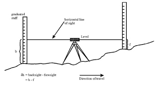
Surveyors use Fly Leveling as a technique to determine the elevation of a point relative to a reference elevation.
It involves setting up the level instrument at a benchmark with a known,
elevation and measuring the difference in elevation between the model and the point of interest using a series of measurements along a straight line.
Determine the difference in elevation between two points by subtracting the elevation of the first point from the elevation of the second point. This technique finds common usage in civil engineering, construction, and land surveying.

Apparatus & Materials Required:
The following apparatus and materials are required for this lab activity:
- Level instrument
- Tripod Stand
- Measuring rod
- Levelling staff
- Notebooks and pens
Procedure:
- Set up the level instrument at a benchmark with a known elevation.
- Record the elevation of the benchmark in a notebook.
- Set up the tripod stand at the point of interest and place the levelling staff on it.
- Align the level instrument with the levelling staff and take a reading of the staff height.
- Record the staff height in a notebook.
- Move the tripod stand away from the benchmark, and repeat steps 3 to 5 until the desired distance is reached.
- Calculate the elevation of the point of interest concerning the benchmark by subtracting the benchmark elevation from the staff height at each point.
- Record the elevation of each point in a notebook.
- Calculate the difference in elevation between each consecutive point.
- Tabulate the data obtained and calculate the average elevation of the point of interest concerning the benchmark.
Results:
The experiment involved using the Fly Leveling technique to determine the elevation of a point concerning a reference elevation. A level instrument was set up at a benchmark with a known elevation, and the staff height was measured at several points along a straight line to the point of interest.
The difference in elevation between each consecutive point was calculated and used to determine the elevation of the point of interest concerning the benchmark. The results obtained from the experiment can be used in civil engineering, construction,
and land surveying to accurately measure elevation differences between two points.
Precautions:
- Ensure that the level instrument is calibrated and working correctly before use.
- Ensure that the tripod stand is stable and firmly secured to the ground.
- Ensure that the measuring rod and levelling staff are clean and free from any obstruction.
- Ensure that the staff is vertical when taking readings.
- Ensure that the readings are taken at the same height on the staff at each point.
- Ensure that the measurements are taken along a straight line between the benchmark and the point of interest.
Conclusion
Successfully conducted an experiment using Fly Leveling to determine point elevation relative to a reference elevation.The results obtained from the experiment demonstrated the accuracy and reliability of the Fly Leveling technique in determining elevation differences between two points
The experiment also provided hands-on experience with the equipment and techniques used in surveying and highlighted the importance of taking precautions to ensure accurate measurements.
Overall, the experiment was a valuable learning experience for understanding the principles and applications of Fly Leveling in surveying. With further training and experience,
participants can use this technique to accurately measure elevation differences in a wide range of civil engineering and construction projects.

