
Introduction
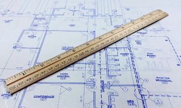
The measurement and establishment of positions, borders, and elevations of land are done using a variety of tools and methods, which are referred to as the “surveying principle.” Using specialist tools like total stations,
levels, and GPS receivers, exact measurements can be taken for this purpose.
The accuracy of a survey is influenced by several variables, including the choice of suitable equipment, expert instrument handling, meticulous field note-taking, accurate data analysis and interpretation, and adherence to set standards and guidelines.
n civil engineering projects, such as building construction sites and road construction, surveyors play a key role in ensuring that concrete foundations are positioned precisely where they are needed.
The basic principles of surveying are:
1. Work from whole to part
Whole-to-part means surveying a large area first, a survey within that area, and then setting more precise reference points. Minimise the chance of error by working from the whole to the parts. Working from the whole,
to parts compensates for the errors made in observing the entire defined area. Therefore, the main principle of surveying is to work from the whole to the part.
Establishing a system of control points and fixing them with greater precision must come first. The details can then be identified using these minor control points by conducting minor traverses, etc.
after minor control points have been generated using less precise techniques. Working in this manner is intended to avoid errors from building up,
control little problems, and localise them before they get larger and become unmanageable after the process if the opposite procedure is used.
2. To mark the location of a point by at least two measurements.
Two control points (any two important features) are chosen in the area and the distance between them is precisely measured. The line connecting the control points is drawn to scale on the drawing sheet.
The desired point can now be plotted by taking two suitable measurements from the given control points
3. There must be adequate provisions for checks.
A measurement must be checked to be guaranteed to be accurate. Nors may have entered an observation while a measurement was being made, recorded, and the measured value was being computed and plotted.
There should be sufficient checks available to guarantee that the observation is accurate. A successful survey is one in which we carefully plan our procedures for collecting data, recording observations,
and performing calculations such that the extras are revealed throughout the process. Measurements should be checked and evaluated properly at the time of recording.
4. Choose the method of the survey that is most suitable for the purpose.
Any desired level of accuracy can be obtained with the skill of modern methods of surveying. Since correct measurements require high-quality precise instruments, surveying is less accurate nowadays because of the lack of funding.
As a result, the survey method must be selected in such a way that the target accuracy is obtained. If the precision is less than what is needed, the survey suits are useless, and if the accuracy is greater than what is intended, they are useful.
5. Record the field data carefully
All data should be recorded carefully and error-free, data should be recorded immediately and nothing should rely on the reliability of one’s memory. Interpretation of values should be avoided.
The objective of surveying explained the following
1. To create a topographical map including hills, rivers, forests, valleys, etc. on it.
2. To create an engineering map using engineering information, such as roads, railroads, canals, dams, and reservoirs.
to create the contour map in order to decide on the optimum path and the necessary quantity of earthwork.
3. To create the political and geographic map.
4. To create an archaeological map indicating the potential locations of ancient architects.
Types of surveying:
In civil engineering, there are mainly two types of surveying
- Plane surveying
- Geodetic or trigonometrical surveying
FAQ
1. Define surveying
Ans – An engineering process known as civil surveying involves evaluating and recording specifics about a piece of land. The planning of construction projects can then benefit from these observations.
2 what are the types of surveying?
Ans – There are mainly two types of surveying based on the accuracy
1. Plane Surveying
2. Geodetic surveying
3. What are the types of principles of surveying ?
Ans – Based on accurate results there are two basic principles
- Work from whole to parts
- Fixing the position of new control points
4. What is the need for surveying in civil engineering?
Ans – the purpose of surveying in civil engineering is to provide a more accurate direction for the construction of the project.
5. What qualifications do professional surveyors need to have?
Ans –: Most professional surveyors have a bachelor’s degree in surveying, geomatics, or a related field. Some may also have a degree in civil engineering or a related discipline.
6. What tools are used in surveying?
Ans – There are several tools used in surveying some of them are the following –
- Total station
- GPS
- Theodolit

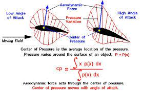
 is a critical concept in fluid mechanics and aerodynamics. It refers to the point at which the total force acting)